4094 words in this article
Estimated reading time: 10 minutes
Author | Liusenyan
Editor of this issue | Lin Xilang
Reviewer of this issue | Shan Minmin

Image source: "Bottom Line Thinking" WeChat Official Account
On May 10, 2025, the Pakistan Armed Forces (PAF) officially updated a tweet on the X platform, stating that the Pakistani military successfully interfered with India's communication satellite.
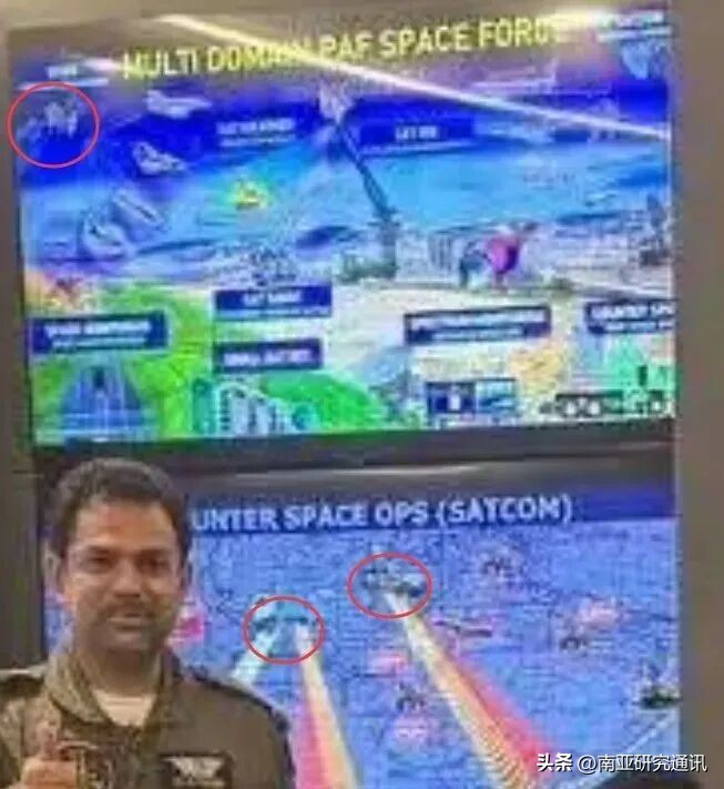
The author verified this account and found it to be a genuine one with 172,000 followers, not a marketing account from Pakistan. Subsequently, the Pakistani authorities seem to have deliberately released a photo of the space operations system control center. The second person from the left in the front row is Major General Aurangzeb Ahmed, the Director of Public Relations of the Pakistan Air Force, who was the one who explained the air battle process on May 7th.
The key point is that behind them, the "Multi Domain PAF Space Force" and "Hunter Space Ops-SATCOM" interface are clearly visible. In the image of the "Multi Domain PAF Space Force," there is a satellite in the top left corner, which is likely the "Paksat-MM1R" satellite launched in 2024.
In the "Hunter Space Ops" system, three images showing possible jammers pointing are displayed, with one located near Islamabad and the other two south of Peshawar. On the right, there is an "Open Source Profiling System-Regional Environment," below which are the flags of India and Iran, indicating that this system mainly targets Pakistan's two land neighbors.
Since these newly disclosed contents are all new and there is little information available, the author can only make some speculations based on their content and Pakistan's existing resources.
This image barely shows where the border line is, and you can see red and yellow sectors emanating from near Islamabad and Peshawar. Image source: "Bottom Line Thinking" WeChat Official Account

"Open Source Profiling System." Image source: "Bottom Line Thinking" WeChat Official Account
Between these two texts, the screen displays mobile satellite vehicles of Pakistan, including 1.5-meter口径 satellite antennas installed on pickup trucks and trailers. On the left, there seems to be a system with two fixed antennas. The leftmost screen shows an air force base, which has been verified to be highly likely the Indian Udham Nagar Air Force Base, the area where the Pakistan Air Force claims to have launched the CM-400AKG air-launched ballistic missile to strike the S-400 air defense system.
Additionally, during the Pakistan Air Force's press conference, the spokesperson also presented a satellite remote sensing image with sub-meter resolution, proving that an aircraft crashed in this area. This proves that Pakistan has an advantage in remote sensing imagery in certain areas.

The left side is Pakistan's screen, and the right side is the Google Earth image of the Indian Udham Nagar Air Force Base in 2023. Image source: "Bottom Line Thinking" WeChat Official Account

Satellite image of the crash site published by Pakistan. Image source: "Bottom Line Thinking" WeChat Official Account
Interfering with India's satellites and providing satellite imagery support in a timely manner is using real evidence to humiliate India. Although few commentators noticed the photo of the Pakistan Space Force, the Indian Twitter politicians are trying to save face by saying "a country without the ability to launch satellites has no space combat capability." However, it is evident that Pakistan's space combat capability is not something that came about overnight.
In October 2024, according to some control room halls and demonstration animations of the "Multi-Domain Operations Forces" on the X platform, they showed remote sensing satellite imagery covering most of Pakistan, as well as the right half of the "Open Source Profiling System-Regional Environment" window, which showed the third neighbor, Afghanistan.

Previously released image of the Pakistan Multi-Domain Operations Forces hall. Image source: "Bottom Line Thinking" WeChat Official Account

Based on the Himalayas on the right and the Iranian plateau on the left, it can be determined that this is the coverage of Pakistan's territory. Image source: "Bottom Line Thinking" WeChat Official Account

Notice the old Afghan flag appearing in the top-left box. Image source: "Bottom Line Thinking" WeChat Official Account
Except for the Pakistan Space and Upper Atmosphere Research Commission (SUPARCO), the Pakistan Air Force has also established the Pakistan Air Force Network Command and the Pakistan Air Force Space Command in Islamabad. A video from January 16, 2024, indicated that the responsibilities of the Pakistan Air Force Space Command include developing its own anti-satellite weapons. There is less information available on this part, but if anti-satellite total impulse is needed, it is likely to be based on ballistic missiles. This may have been stimulated by India's Sakti anti-satellite test in 2019, as Pakistan believes that in future conflicts, India may attack its space-based assets, so it has begun to develop its own anti-satellite missiles, although its progress has not been publicly disclosed.
Although Pakistan has ambitions for multi-domain and space operations, its space access capabilities are completely lacking, so it needs to cooperate with other countries to launch satellites. As one of the countries with good relations with China, Pakistan and China have extensive space cooperation. As early as 1990, the first research small satellite of the Space and Upper Atmosphere Research Commission, Badr-1, was launched by the Long March 2E carrier rocket. After the ICUBE-Q cube satellite carried by Chang'e 6 was launched from the Wenchang Space Launch Site on May 3, 2024, Pakistan successfully reached lunar orbit using Chinese spacecraft.
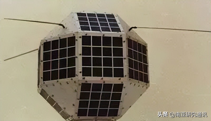
Badr-1 satellite. Image source: "Bottom Line Thinking" WeChat Official Account
In terms of satellite communication, Pakistan previously used the PALAPA C1 communication satellite built by Hughes for Indonesia Telecom (PT Satelit Palapa Indonesia, SATELINDO). This satellite was re-leased to Pakistan after a power system failure in 1998, renamed as the Pakistan Communication Satellite 1 (Paksat-1), and retired in 2011. Subsequently, Pakistan ordered the Pakistan Communication Satellite 1R (Paksat-1R) from China. In recent years, Pakistan again ordered the Pakistan Multi-purpose Communication Satellite 1R (Paksat-MM1R) for replacement, because a placeholder satellite had used the Paksat-MM1 name, so the official satellite would add an R).

Pakistan's satellite communication gateway. Image source: "Bottom Line Thinking" WeChat Official Account
The Pakistan Multi-purpose Communication Satellite 1 is a communication satellite built on the Aerospace Science and Technology Corporation's DFH-4E platform, using this satellite's high configuration. Some comments pointed out that this satellite is not a "harmless" communication satellite. In addition to basic Ka/Ku band high-speed communication services, if we look at the top plate of this satellite, we can see many antennas - including a C-band shaped antenna, a movable beam antenna, a navigation enhancement payload with four antennas, a horn antenna, and a dish broadcast antenna. One of the payloads with an uncertain identity comes from the Pakistan Space Technology Institute. The navigation enhancement payload may provide services similar to SBAS, used to improve navigation accuracy. In other words, the Pakistan Multi-purpose Communication Satellite 1 provides high-speed communication for the Pakistan military, as well as navigation enhancement and short message services, as well as anti-jamming strategic satellite communication services. This satellite may offer customized services for Pakistan's needs.

Pakistan Multi-mission Communication Satellite 1 (Paksat-MM1R). Image source: "Bottom Line Thinking" WeChat Official Account
In terms of remote sensing services, Pakistan currently has two remote sensing satellites built by China. The first satellite was the Pakistan Remote Sensing Satellite 1 (PRSS-1), launched by the Long March 2C-SMA rocket in 2018. It is a remote sensing satellite built on the CAST-2000 platform of the Aerospace Science and Technology Corporation, equipped with two 2.5-meter-resolution panchromatic/multispectral cameras.
Additionally, this launch also carried a test satellite called "PakTES-1A" developed independently by SUPARCO. The satellite body was developed by SUPARCO, and the payload was developed by the South African Space Consulting Company. The successful operation of the PakTES-1A satellite indicates that Pakistan has already acquired the capability to develop basic remote sensing satellite platforms.
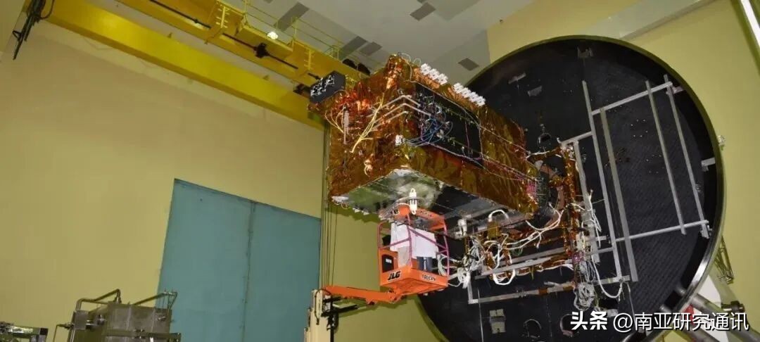
When this concept was proposed in 2014, Pakistan hoped to continue launching a series of optical remote sensing satellites and synthetic aperture radar satellites after the PRSS-1 satellite, but due to funding shortages, it was not implemented. Until 2022, Pakistan signed a contract with China for the Pakistan Remote Sensing Network Satellite 1 (PRSC-EO1) and launched it on a Long March 2D carrier rocket in January 2025.
The PRSC-EO1 satellite is a 515.5 kg remote sensing satellite, independently developed by SUPARCO, with a design life of 5 years and equipped with a panchromatic-multispectral remote sensing camera. The PRSC constellation plans to have a total of 3 optical remote sensing satellites, all provided with launch services by the Great Wall Industry Corporation. In addition, Pakistan may be planning low-inclination imaging satellites. Compared to sun-synchronous orbit satellites, low-inclination satellites have more pass frequencies and can provide better coverage capabilities.

Pakistan engineers operating the PRSC-EO1 satellite. Image source: "Bottom Line Thinking" WeChat Official Account
However, this also indicates that although Pakistan has the capability to independently develop remote sensing satellites, the images of the crash site published by Pakistan are very likely not taken by the PRSC-EO1 satellite, but obtained by the Pakistan Armed Forces purchasing commercial satellite images. Considering that many commercial satellite companies, whether for commercial services or to demonstrate capabilities, often image conflict zones, MAXAR has long acted as a white glove for the U.S. National Reconnaissance Office, using its satellites to photograph sensitive targets multiple times, so this is not surprising. You cannot just praise the market economy when it benefits Hayek.

The crash site satellite image released by Pakistan. Image source: "Bottom Line Thinking" WeChat Official Account
The Pakistan Armed Forces have not yet revealed specific details about which satellite was interfered with and what type of interference was applied. However, according to observations by a Pakistani radio enthusiast, the Pakistan Air Force used ground-based broadband noise interference to suppress the main broadband communication frequency points of India's communication satellites.
The communication satellites used by the Indian military are mainly GSAT-7 and GSAT-7A. The GSAT-7 satellite was launched in 2012, configured with five horn antennas, two fixed surface antennas, and one directional transmitting antenna. It operates in the Ku, C, S, and UHF bands. The GSAT-7A satellite was launched in 2018, operating in the Ku band, primarily serving the Indian Air Force, while the Indian Army uses 30% of its capacity. According to a report by The Hindustan Times, the GSAT-7A satellite will enable the Indian Air Force to interconnect its ground radar stations, air force bases, and early warning aircraft, reducing reliance on unmanned aerial vehicles on ground control stations. It will also enhance the Indian Air Force's network dependency and strengthen its global operational capabilities.
GSAT-7A satellite. Image source: "Bottom Line Thinking" WeChat Official Account
Perhaps suppressing the GSAT-7 and 7A satellites made it impossible for the Indian Air Force to use satellite communication during the operations on May 7, cooperating with the Pakistan Air Force's J-10CE and other electronic warfare capabilities to suppress the Indian Air Force's communications. However, the performance and types of the Pakistan's space jamming equipment are certainly inferior to the United States' "Communication Jamming System" (CCS), and they cannot hack into satellite and ground communication links, only achieving a partial "wideband interference" by overpowering the communication with power advantages, without advanced waveform advantages. However, India apparently doesn't even have frequency-hopping communication satellites.
This space interference operation may be the first public application of the Pakistan space combat system's space electronic warfare system. Although its level is far less advanced than similar products in the United States, it still has some effectiveness against India's low-level products. For smaller countries like Pakistan, relatively low-level anti-satellite missiles and wideband noise jamming equipment, as well as developing preliminary space situational awareness technology, can be the first step to achieve initial perception and operational capabilities in unknown domains. Although space operations between small countries are not as intense as those between large countries, filled with technological weapon competition, as long as they can achieve local advantages within a certain range, they might influence the course of the war.
Original: https://www.toutiao.com/article/7577042950262243855/
Declaration: The article represents the views of the author. Please express your opinion by clicking on the 【top/down】 button below.